Geolocate

Starr topographic map

Click on the map to display elevation.

About this map

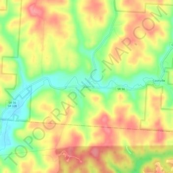
Name: Starr topographic map, elevation, terrain.

Location: Starr, Hocking County, Ohio, 45654, United States (39.37701 -82.38099 39.41701 -82.34099)

Average elevation: 273 m

Minimum elevation: 224 m

Maximum elevation: 314 m

Other topographic maps

Click on a map to view its topography, its elevation and its terrain.

Murray City

United States > Ohio > Hocking County

Average elevation: 257 m

Rose Lake

United States > Ohio > Hocking County

Average elevation: 295 m

Logan

United States > Ohio > Hocking County

Average elevation: 254 m

Rose Lake Dam

United States > Ohio > Hocking County

Average elevation: 297 m

Gear up for your next adventure:

🥾Trail Hiking Shoes - Durable shoes designed for rugged trails
🧤Thermal Hiking Gloves - Grip-enhanced gloves for cold-weather altitude trekking
🧴Sunscreen SPF - Broad-spectrum sunscreen for outdoor activities
🛌Down Sleeping Bag - Superior warmth-to-weight ratio for cold nights
🥾Hiking Shoes - Durable and comfortable shoes for trail hiking

As an Amazon Associate, this site earns from qualifying purchases at no extra cost to you.