Geolocate

Kaithal topographic map

Click on the map to display elevation.

Kaithal

Kaithal is located at 29°48′05″N 76°23′59″E / 29.8015°N 76.3996°E / 29.8015; 76.3996. It has an average elevation of 220 metres (721 feet).

Wikipedia (CC-BY-SA 3.0)

About this map

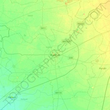
Name: Kaithal topographic map, elevation, terrain.

Location: Kaithal, Haryana, 132027, India (29.63966 76.23899 29.95966 76.55899)

Average elevation: 238 m

Minimum elevation: 228 m

Maximum elevation: 252 m

Gear up for your next adventure:

Camping Coffee Maker - Brew fresh coffee anywhere on the topographic map
🥾Trail Running Boots - Durable shoes designed for trail running
🥾Mountain Hiking Boots - High-traction boots for rocky terrain
🥾Trekking Boots - Durable boots for long-distance trekking
🪑Ultralight Camping Stool - Compact seating for rest stops during long hikes

As an Amazon Associate, this site earns from qualifying purchases at no extra cost to you.