Geolocate

Tiffany Acres topographic map

Click on the map to display elevation.

About this map

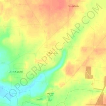
Name: Tiffany Acres topographic map, elevation, terrain.

Location: Tiffany Acres, Clark County, Ohio, 45323, United States (39.84700 -83.90743 39.88700 -83.86743)

Average elevation: 301 m

Minimum elevation: 271 m

Maximum elevation: 320 m

Other topographic maps

Click on a map to view its topography, its elevation and its terrain.

Springfield

United States > Ohio > Clark County

Average elevation: 310 m

South Charleston

United States > Ohio > Clark County

Average elevation: 342 m

Springfield

United States > Ohio > Clark County

Average elevation: 310 m

Gear up for your next adventure:

👟Sport Hiking Sandals - Breathable footwear for water crossings and camp rest
🥽Outdoor Goggles - Protective eyewear for outdoor activities
🥾Waterproof Hiking Boots - Essential footwear for rugged terrain and wet Canadian trails
🏃Hydration Running Vest - Carry water and maps close to your body for speed
🧭GPS Handheld Device - Reliable GPS navigation for outdoor adventures

As an Amazon Associate, this site earns from qualifying purchases at no extra cost to you.