
Make a donation
Gear up for your next adventure:
As an Amazon Associate, this site earns from qualifying purchases at no extra cost to you.
Furnas topographic map
Click on the map to display elevation.
Make a donation
Gear up for your next adventure:
As an Amazon Associate, this site earns from qualifying purchases at no extra cost to you.
Furnas
The western of the two calderas is partially filled by a crater lake, Lagoa das Furnas, at an elevation of 359 metres (1,178 ft) and populated by several fumaroles and mud pools are located at the northern part of the lake. In the central part of the village, springs and geysers are prevalent; thirty springs, each of differing temperatures and chemical compositions, including warm iron-rich streams and piped examples of mineral-rich warm and cold water. The geysers are situated in several basins rich in sodium bicarbonate, boron, fluorine and traces of carbon dioxide. The local inhabitants cook stew-type dishes in the geysers. The installations of hydrotherapy are in the park and were built in the 19th century.
Make a donation
Gear up for your next adventure:
As an Amazon Associate, this site earns from qualifying purchases at no extra cost to you.
About this map
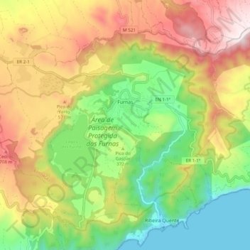
Name: Furnas topographic map, elevation, terrain.
Location: Furnas, Povoação, Azores, Portugal (37.73406 -25.37230 37.79687 -25.27597)
Average elevation: 388 m
Minimum elevation: -2 m
Maximum elevation: 875 m
Make a donation
Gear up for your next adventure:
As an Amazon Associate, this site earns from qualifying purchases at no extra cost to you.
Other topographic maps
Click on a map to view its topography, its elevation and its terrain.