
Make a donation
Gear up for your next adventure:
As an Amazon Associate, this site earns from qualifying purchases at no extra cost to you.
Reda topographic map
Click on the map to display elevation.
Make a donation
Gear up for your next adventure:
As an Amazon Associate, this site earns from qualifying purchases at no extra cost to you.
About this map
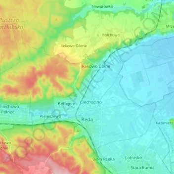
Name: Reda topographic map, elevation, terrain.
Location: Reda, Wejherowo County, Pomeranian Voivodeship, 84-240, Poland (54.58665 18.25645 54.65530 18.41237)
Average elevation: 46 m
Minimum elevation: -3 m
Maximum elevation: 156 m
Make a donation
Gear up for your next adventure:
As an Amazon Associate, this site earns from qualifying purchases at no extra cost to you.
Other topographic maps
Click on a map to view its topography, its elevation and its terrain.
Zbiornik Czymanowo
Poland > Pomeranian Voivodeship > Wejherowo County > Strzebielinek
Average elevation: 94 m
Make a donation
Gear up for your next adventure:
As an Amazon Associate, this site earns from qualifying purchases at no extra cost to you.