
Gulpen-Wittem topographic map
Interactive map
Click on the map to display elevation.
About this map
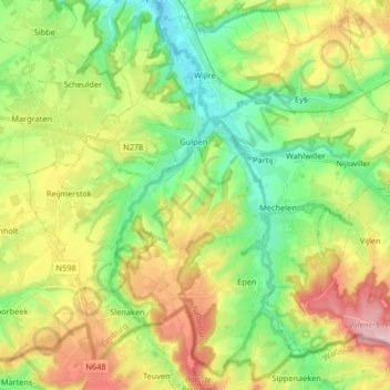
Name: Gulpen-Wittem topographic map, elevation, terrain.
Location: Gulpen-Wittem, Limburg, Niederlande (50.75037 5.81941 50.84889 5.98352)
Average elevation: 164 m
Minimum elevation: 79 m
Maximum elevation: 297 m
Other topographic maps
Click on a map to view its topography, its elevation and its terrain.
Mechelen
Niederlande > Limburg > Gulpen-Wittem
Mechelen, Gulpen-Wittem, Limburg, Niederlande
Average elevation: 157 m
Epen
Niederlande > Limburg > Gulpen-Wittem
Epen, Gulpen-Wittem, Limburg, Niederlande
Average elevation: 174 m