
Make a donation
Gear up for your next adventure:
As an Amazon Associate, this site earns from qualifying purchases at no extra cost to you.
Fohlenplacken topographic map
Click on the map to display elevation.
Make a donation
Gear up for your next adventure:
As an Amazon Associate, this site earns from qualifying purchases at no extra cost to you.
Fohlenplacken
Das Dorf Fohlenplacken liegt rund 1,5 km (Luftlinie) nordwestlich vom Ortskern Neuhaus’ an der Holzminde auf 295 bis 340 m Höhe. Die Kreisstraße 50 zwischen Neuhaus und Holzminden führt durch die Ortslage.
Make a donation
Gear up for your next adventure:
As an Amazon Associate, this site earns from qualifying purchases at no extra cost to you.
About this map
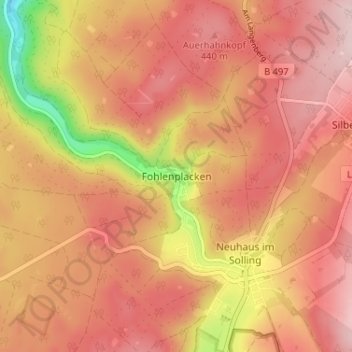
Name: Fohlenplacken topographic map, elevation, terrain.
Average elevation: 396 m
Minimum elevation: 225 m
Maximum elevation: 480 m
Make a donation
Gear up for your next adventure:
As an Amazon Associate, this site earns from qualifying purchases at no extra cost to you.
Other topographic maps
Click on a map to view its topography, its elevation and its terrain.
Silberborn
Deutschland > Niedersachsen > Landkreis Holzminden > Holzminden
Der Ortsteil Torfhaus, der aus wenigen Gebäuden besteht, liegt auf der Silberborner Hochebene 1,25 Kilometer östlich vom Silberborner Ortskern an der Landesstraße 549 auf etwa 490 m Höhe, womit er die höchstgelegene Ortschaft des Solling ist.
Average elevation: 449 m