
Penk topographic map
Interactive map
Click on the map to display elevation.
About this map
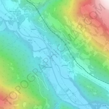
Name: Penk topographic map, elevation, terrain.
Average elevation: 1,029 m
Minimum elevation: 622 m
Maximum elevation: 2,195 m
Other topographic maps
Click on a map to view its topography, its elevation and its terrain.
Schoberspitze
Österreich > Kärnten > Bezirk Spittal an der Drau > Reißeck
Schoberspitze, Reißeck, Bezirk Spittal an der Drau, Kärnten, 9815, Österreich
Average elevation: 2,091 m
Hochalmsee
Österreich > Kärnten > Bezirk Spittal an der Drau > Reißeck
Hochalmsee, Reißeck, Bezirk Spittal an der Drau, Kärnten, 9816, Österreich
Average elevation: 2,338 m
Preisdorf
Österreich > Kärnten > Bezirk Spittal an der Drau > Reißeck > Preisdorf
Preisdorf, Reißeck, Bezirk Spittal an der Drau, Kärnten, 9815, Österreich
Average elevation: 997 m