
Make a donation
Gear up for your next adventure:
As an Amazon Associate, this site earns from qualifying purchases at no extra cost to you.
Kаala-Gomen topographic map
Click on the map to display elevation.
Make a donation
Gear up for your next adventure:
As an Amazon Associate, this site earns from qualifying purchases at no extra cost to you.
About this map
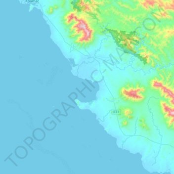
Name: Kаala-Gomen topographic map, elevation, terrain.
Average elevation: 86 m
Minimum elevation: 0 m
Maximum elevation: 1,073 m
Make a donation
Gear up for your next adventure:
As an Amazon Associate, this site earns from qualifying purchases at no extra cost to you.
Other topographic maps
Click on a map to view its topography, its elevation and its terrain.
Make a donation
Gear up for your next adventure:
As an Amazon Associate, this site earns from qualifying purchases at no extra cost to you.
Mont Panié
France > Province Nord > Hienghène
Le mont Panié, localement appelé Taaluny, est un sommet de Nouvelle-Calédonie s'élevant à 1 629 mètres d'altitude au nord de l'île de Grande Terre, dans la Chaîne centrale, et constituant le point culminant de cette collectivité d'outre-mer. Il est constitué de roches métamorphiques. Situé face aux…
Average elevation: 1,236 m