Geolocate

Husum topographic map

Click on the map to display elevation.

About this map

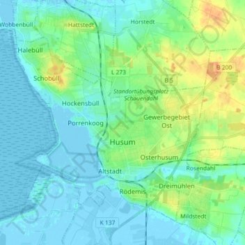
Name: Husum topographic map, elevation, terrain.

Location: Husum, Northern Friesland, Schleswig-Holstein, 25813, Germany (54.45842 8.95897 54.52546 9.10165)

Average elevation: 8 m

Minimum elevation: -4 m

Maximum elevation: 32 m

Other topographic maps

Click on a map to view its topography, its elevation and its terrain.

Gear up for your next adventure:

🥾Light Hiking Boots - Lightweight and comfortable boots for day hikes
🎒Backpack Rain Cover - External shield to keep your entire pack dry
🥾Trail Running Shoes - Lightweight and durable shoes for trail running
Camping Essentials - All-in-one gear for a comfortable camping trip
🥾Approach Boots - Comfortable boots for hiking and climbing approaches

As an Amazon Associate, this site earns from qualifying purchases at no extra cost to you.