Geolocate

Lala topographic map

Click on the map to display elevation.

About this map

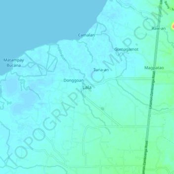
Name: Lala topographic map, elevation, terrain.

Location: Lala, Lanao del Norte, Northern Mindanao, Philippines (7.93337 123.70765 8.01337 123.78765)

Average elevation: 5 m

Minimum elevation: -1 m

Maximum elevation: 51 m

Other topographic maps

Click on a map to view its topography, its elevation and its terrain.

Agus River

Philippines > Lanao del Norte

Average elevation: 499 m

Linamon

Philippines > Lanao del Norte

Average elevation: 42 m

Kolambugan

Philippines > Lanao del Norte

Average elevation: 55 m

Baloi

Philippines > Lanao del Norte > Baloi

Average elevation: 393 m

Agus River

Philippines > Lanao del Norte > West Pantar

Average elevation: 536 m

Gear up for your next adventure:

🛌Insulated Sleeping Pad - Critical thermal barrier between you and the cold ground
Bushcraft Tarp - Versatile emergency shelter or gear protection
🎒Hiking Daypack - Lightweight and durable backpacks for day trips and excursions
🧤Thermal Hiking Gloves - Grip-enhanced gloves for cold-weather altitude trekking
🥾Approach Shoes - Shoes designed for climbing approaches and rugged trails

As an Amazon Associate, this site earns from qualifying purchases at no extra cost to you.