Geolocate

Murray Key topographic map

Click on the map to display elevation.

About this map

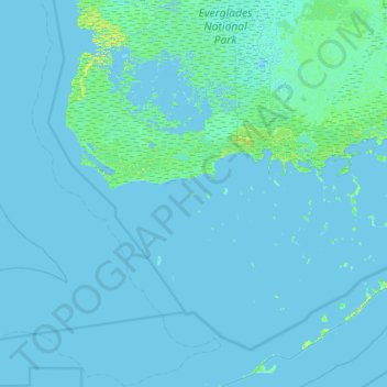
Name: Murray Key topographic map, elevation, terrain.

Location: Murray Key, Monroe County, Florida, United States (24.78846 -81.25785 25.42846 -80.61785)

Average elevation: 1 m

Minimum elevation: -3 m

Maximum elevation: 12 m

Other topographic maps

Click on a map to view its topography, its elevation and its terrain.

Key

United States > Florida > Monroe County

Average elevation: 0 m

Key Largo

United States > Florida > Monroe County > Key Largo

Average elevation: 1 m

Layton

United States > Florida > Monroe County

Average elevation: 1 m

Key Largo

United States > Florida > Monroe County

Average elevation: 1 m

Duck Key

United States > Florida > Monroe County > Duck Key

Average elevation: 0 m

Fish Hawk Key

United States > Florida > Monroe County

Average elevation: 0 m

Sawyer Key

United States > Florida > Monroe County

Average elevation: 0 m

Tavernier

United States > Florida > Monroe County > Tavernier

Average elevation: 2 m

Crab Key

United States > Florida > Monroe County

Average elevation: 0 m

Gear up for your next adventure:

🧴First Aid Kit - Essential first aid supplies for outdoor emergencies
Tent Footprint - Protect tent floor and increase durability
Lightweight Camping Tent - Portable shelter optimized for Canadian backcountry camping
👟Sport Hiking Sandals - Breathable footwear for water crossings and camp rest
🥾Lightweight Hiking Boots - Boots for comfort and mobility on long hikes

As an Amazon Associate, this site earns from qualifying purchases at no extra cost to you.