
Währing topographic map
Interactive map
Click on the map to display elevation.
About this map
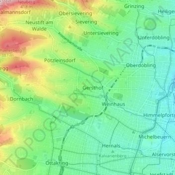
Name: Währing topographic map, elevation, terrain.
Location: Währing, Vienne, 1180, Autriche (48.21725 16.28237 48.25098 16.35377)
Average elevation: 247 m
Minimum elevation: 169 m
Maximum elevation: 429 m
Other topographic maps
Click on a map to view its topography, its elevation and its terrain.
Sophienpark
Sophienpark, KG Neubau, Neubau, Vienne, 1070, Autriche
Average elevation: 207 m