
Make a donation
Gear up for your next adventure:
As an Amazon Associate, this site earns from qualifying purchases at no extra cost to you.
Nandi Hills topographic map
Click on the map to display elevation.
Make a donation
Gear up for your next adventure:
As an Amazon Associate, this site earns from qualifying purchases at no extra cost to you.
Nandi Hills
Nandi Hills is located in a highland area of Lush Green Rolling Hills at the edge of the Great Rift Valley in the southwestern part of Kenya. It is located approximately 303 kilometres (188 mi), by road, northwest of Nairobi, the capital and largest city in the country. The coordinates of Nandi Hills, Kenya are: 0°06'01.0"N, 35°10'35.0"E (Latitude: 0.100278; Longitude: 35.176389). Nandi Hills lies an elevation of approximately 2,047 metres (6,716 ft), above sea level.
Make a donation
Gear up for your next adventure:
As an Amazon Associate, this site earns from qualifying purchases at no extra cost to you.
About this map
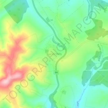
Name: Nandi Hills topographic map, elevation, terrain.
Average elevation: 2,028 m
Minimum elevation: 1,940 m
Maximum elevation: 2,184 m
Make a donation
Gear up for your next adventure:
As an Amazon Associate, this site earns from qualifying purchases at no extra cost to you.