Geolocate

Parsac-Rimondeix topographic map

Click on the map to display elevation.

Parsac-Rimondeix

L'altitude minimale avec 353 mètres se trouve localisée au nord-est, là où le Verraux quitte le territoire comunal et entre sur celui de Domeyrot. L'altitude maximale avec 503 mètres est située dans le sud-ouest, au sud-ouest du lieu-dit les Bruyères.

Wikipedia (CC-BY-SA 3.0)

About this map

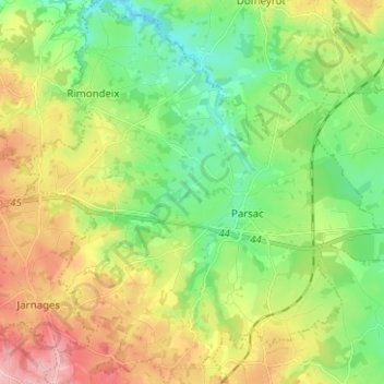
Name: Parsac-Rimondeix topographic map, elevation, terrain.

Location: Parsac-Rimondeix, Parsac, Aubusson, Creuse, Nouvelle-Aquitaine, France métropolitaine, 23140, France (46.16317 2.08055 46.24976 2.20514)

Average elevation: 424 m

Minimum elevation: 354 m

Maximum elevation: 536 m

Other topographic maps

Click on a map to view its topography, its elevation and its terrain.

Les Andrieux

France > Nouvelle-Aquitaine > Creuse > Parsac

Average elevation: 403 m

Gear up for your next adventure:

🥾Trail Running Shoes - Lightweight and durable shoes for trail running
🔋Lithium AA Batteries - Long-lasting power that performs in extreme cold
🧭GPS Outdoor Watch - Smart watch for navigation and fitness tracking in nature
🧦Crew Hiking Socks - Comfortable socks for long-distance hikes
🪑Ultralight Camping Stool - Compact seating for rest stops during long hikes

As an Amazon Associate, this site earns from qualifying purchases at no extra cost to you.