
Thank you for supporting this site ❤️
Make a donation
Make a donation
Gear up for your next adventure:
As an Amazon Associate, this site earns from qualifying purchases at no extra cost to you.
Al `Arif topographic map
Click on the map to display elevation.
Thank you for supporting this site ❤️
Make a donation
Make a donation
Gear up for your next adventure:
As an Amazon Associate, this site earns from qualifying purchases at no extra cost to you.
About this map
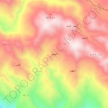
Name: Al `Arif topographic map, elevation, terrain.
Location: Al `Arif, Ar Rujum District, Al Mahwit Governorate, Yemen (15.39817 43.63391 15.43817 43.67391)
Average elevation: 1,804 m
Minimum elevation: 1,318 m
Maximum elevation: 2,080 m
Thank you for supporting this site ❤️
Make a donation
Make a donation
Gear up for your next adventure:
As an Amazon Associate, this site earns from qualifying purchases at no extra cost to you.
Other topographic maps
Click on a map to view its topography, its elevation and its terrain.