Geolocate

Velpen topographic map

Click on the map to display elevation.

About this map

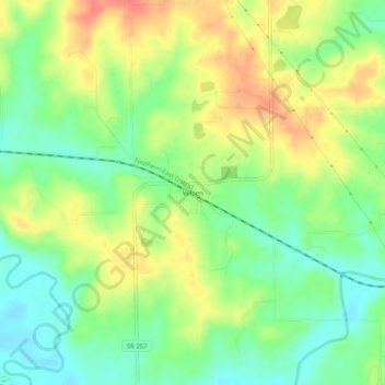
Name: Velpen topographic map, elevation, terrain.

Location: Velpen, Pike County, Indiana, 47590, United States (38.33533 -87.12195 38.37533 -87.08195)

Average elevation: 153 m

Minimum elevation: 126 m

Maximum elevation: 185 m

Other topographic maps

Click on a map to view its topography, its elevation and its terrain.

Petersburg

United States > Indiana > Pike County

Average elevation: 144 m

Winslow

United States > Indiana > Pike County

Average elevation: 138 m

Gear up for your next adventure:

🥾Waterproof Hiking Boots - Boots keeping your feet dry in wet conditions
🦯Trekking Poles - Reduced impact on joints for steep topographic climbs
🕶️Polarized Sunglasses - Reduces glare from snow and water at high elevations
🧣Merino Neck Gaiter - Protects against wind, sun, and cold at high altitudes
🧴Outdoor Sunscreen - High SPF protection for high-altitude UV exposure

As an Amazon Associate, this site earns from qualifying purchases at no extra cost to you.