
Make a donation
Gear up for your next adventure:
As an Amazon Associate, this site earns from qualifying purchases at no extra cost to you.
Manyeleti topographic map
Click on the map to display elevation.
Make a donation
Gear up for your next adventure:
As an Amazon Associate, this site earns from qualifying purchases at no extra cost to you.
About this map
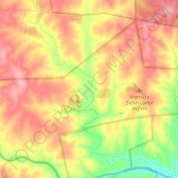
Name: Manyeleti topographic map, elevation, terrain.
Average elevation: 376 m
Minimum elevation: 304 m
Maximum elevation: 433 m
Make a donation
Gear up for your next adventure:
As an Amazon Associate, this site earns from qualifying purchases at no extra cost to you.
Other topographic maps
Click on a map to view its topography, its elevation and its terrain.
Mariepskop
South Africa > Mpumalanga > Ehlanzeni District Municipality > Bushbuckridge
Several distinguishable plant communities have been described. The foothills are covered in low altitude woodlands, which are distinguished as lowveld gallery forest, savanna on mountain slopes, savanna on rocky terrain and submontane forest. In the mountain's higher reaches the high mountain grassland is…
Average elevation: 1,445 m
MalaMala Game Reserve
South Africa > Mpumalanga > Ehlanzeni District Municipality > Bushbuckridge
Average elevation: 338 m
Umbabat Nature Reserve
South Africa > Mpumalanga > Ehlanzeni District Municipality > Bushbuckridge
Average elevation: 343 m
MalaMala Game Reserve
South Africa > Mpumalanga > Ehlanzeni District Municipality > Bushbuckridge
Average elevation: 338 m
Make a donation
Gear up for your next adventure:
As an Amazon Associate, this site earns from qualifying purchases at no extra cost to you.
Mopane Dam
South Africa > Mpumalanga > Ehlanzeni District Municipality > Bushbuckridge
Average elevation: 337 m
Satara Rest Camp
South Africa > Mpumalanga > Ehlanzeni District Municipality > Bushbuckridge
Average elevation: 268 m
Mariepskop
South Africa > Mpumalanga > Ehlanzeni District Municipality > Bushbuckridge
Several distinguishable plant communities have been described. The foothills are covered in low altitude woodlands, which are distinguished as lowveld gallery forest, savanna on mountain slopes, savanna on rocky terrain and submontane forest. In the mountain's higher reaches the high mountain grassland is…
Average elevation: 1,445 m