
Thank you for supporting this site ❤️
Make a donation
Make a donation
Gear up for your next adventure:
As an Amazon Associate, this site earns from qualifying purchases at no extra cost to you.
Höfen (Enz) topographic map
Click on the map to display elevation.
Thank you for supporting this site ❤️
Make a donation
Make a donation
Gear up for your next adventure:
As an Amazon Associate, this site earns from qualifying purchases at no extra cost to you.
Höfen (Enz)
Höfen liegt im Enztal im Nordschwarzwald in 360 bis 712 Meter Höhe, unterhalb des Zusammenflusses der Großen Enz und der Kleinen Enz. Die Gemeindefläche ist zu 85 % bewaldet.
Thank you for supporting this site ❤️
Make a donation
Make a donation
Gear up for your next adventure:
As an Amazon Associate, this site earns from qualifying purchases at no extra cost to you.
About this map
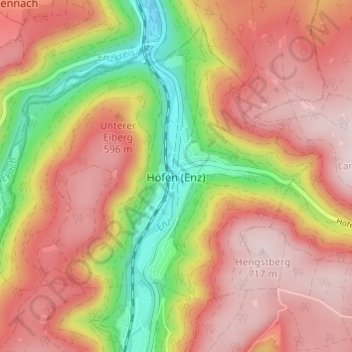
Name: Höfen (Enz) topographic map, elevation, terrain.
Average elevation: 562 m
Minimum elevation: 344 m
Maximum elevation: 716 m
Thank you for supporting this site ❤️
Make a donation
Make a donation
Gear up for your next adventure:
As an Amazon Associate, this site earns from qualifying purchases at no extra cost to you.