
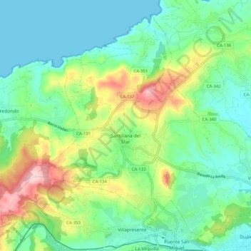
Santillana del Mar topographic map
Interactive map
Click on the map to display elevation.
About this map
Name: Santillana del Mar topographic map, elevation, terrain.
Average elevation: 84 m
Minimum elevation: 0 m
Maximum elevation: 285 m
Other topographic maps
Click on a map to view its topography, its elevation and its terrain.
Unquera
Espagne > Cantabria > Costa Occidental > Val de San Vicente
Unquera, Val de San Vicente, Costa Occidental, Cantabria, Cantabrie, 39560, Espagne
Average elevation: 71 m
Herrán
Espagne > Cantabria > Costa Occidental > Santillana del Mar
Herrán, Santillana del Mar, Costa Occidental, Cantabria, Cantabrie, 39360, Espagne
Average elevation: 109 m
Comillas
Espagne > Cantabria > Costa Occidental
Comillas, Costa Occidental, Cantabria, Cantabrie, 39528, Espagne
Average elevation: 84 m