Geolocate

Gajwel topographic map

Click on the map to display elevation.

About this map

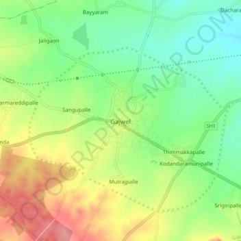
Name: Gajwel topographic map, elevation, terrain.

Location: Gajwel, Gajwel mandal, Siddipet, Telangana, 502278, India (17.80567 78.64287 17.88567 78.72287)

Average elevation: 568 m

Minimum elevation: 532 m

Maximum elevation: 620 m

Gear up for your next adventure:

💡LED Headlamp - Hands-free illumination for night hiking and camping
🛰️Satellite Messenger - Emergency communication for areas with no cell service
🥾Approach Boots - Comfortable boots for hiking and climbing approaches
🧴Bear Spray Holster - Quick-access carry for essential Canadian wilderness safety
🎒Fully Waterproof Backpack - Total protection for photography gear and electronics

As an Amazon Associate, this site earns from qualifying purchases at no extra cost to you.