Geolocate

Grand Haven topographic map

Click on the map to display elevation.

About this map
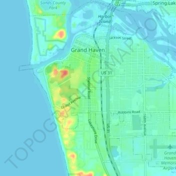
Name: Grand Haven topographic map, elevation, terrain.

Location: Grand Haven, Ottawa County, Michigan, United States (43.02605 -86.25627 43.07753 -86.18520)

Average elevation: 182 m

Minimum elevation: 175 m

Maximum elevation: 224 m

Other topographic maps

Click on a map to view its topography, its elevation and its terrain.
Borculo

United States > Michigan > Ottawa County > Olive Township

Average elevation: 197 m

Macatawa

United States > Michigan > Ottawa County > Park Township

Average elevation: 181 m

Aman Park

United States > Michigan > Ottawa County > Tallmadge

Average elevation: 207 m

Wright

United States > Michigan > Ottawa County > Wright Township

Average elevation: 265 m

Port Sheldon

United States > Michigan > Ottawa County

Average elevation: 185 m

Grand Valley

United States > Michigan > Ottawa County

Average elevation: 199 m

Gear up for your next adventure:

🛏️Camping Sleeping Mat - Comfortable mats for sleeping outdoors
🥾Durable Hiking Shoes - Long-lasting shoes for frequent hiking
🥾Hiking Gaiters - Protect legs and shoes from mud, snow, and debris
💧Filtered Water Bottle - Safe drinking water on the go
🦟Insect Repellent - Keep mosquitoes and black flies away in wooded areas

As an Amazon Associate, this site earns from qualifying purchases at no extra cost to you.