
Make a donation
Gear up for your next adventure:
As an Amazon Associate, this site earns from qualifying purchases at no extra cost to you.
Oensingen topographic map
Click on the map to display elevation.
Make a donation
Gear up for your next adventure:
As an Amazon Associate, this site earns from qualifying purchases at no extra cost to you.
Oensingen
Nebst vielen anderen Betrieben des industriellen und logistischen Bereichs hat auch die grösste Fleischverarbeiterin der Schweiz, die Bell Food Group, wichtige Betriebsteile am Standort Oensingen. Auffällig vor allem auch der grosse Rindvieh-Schlachthof: 2500 bis 3000 dieser Tiere (inklusive Kälber) werden hier wöchentlich geschlachtet. Und dies wird sich in nächster Zeit noch einmal erhöhen, weil der neu erstellte Schlachthof kurz vor der Inbetriebnahme steht.
Make a donation
Gear up for your next adventure:
As an Amazon Associate, this site earns from qualifying purchases at no extra cost to you.
About this map
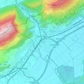
Name: Oensingen topographic map, elevation, terrain.
Location: Oensingen, Bezirk Gäu, Amtei Thal-Gäu, Solothurn, 4702, Schweiz (47.25911 7.68477 47.30893 7.75223)
Average elevation: 558 m
Minimum elevation: 436 m
Maximum elevation: 1,085 m
Make a donation
Gear up for your next adventure:
As an Amazon Associate, this site earns from qualifying purchases at no extra cost to you.
Other topographic maps
Click on a map to view its topography, its elevation and its terrain.
Mümliswil
Schweiz > Solothurn > Amtei Thal-Gäu
Mümliswil liegt auf 556 m ü. M., 3 km nördlich des Bezirkshauptortes Balsthal (Luftlinie). Das Haufendorf erstreckt sich in einem weiten Talkessel am Zusammenfluss von Ramiswiler Bach, Limmerenbach und Rickenbächli, am oberen Eingang in die Klus von Lobisei, am Südfuss der Höhen des Passwangs im…
Average elevation: 744 m
Gänsbrunnen
Schweiz > Solothurn > Amtei Thal-Gäu
Östlich des Talkessels von Gänsbrunnen reichte die Gemeindefläche über eine niedrige Passhöhe in das Quellgebiet der Dünnern. Dieses wird im Süden vom Dilitschkopf (mit 1333 m ü. M. die höchste Erhebung von Gänsbrunnen), der zum Weissenstein gehört, im Norden von der Walenmatt (1239 m ü. M.)…
Average elevation: 961 m
Make a donation
Gear up for your next adventure:
As an Amazon Associate, this site earns from qualifying purchases at no extra cost to you.