
Athabasca Sand Dunes topographic map
Click on the map to display elevation.
About this map
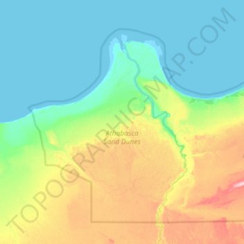
Name: Athabasca Sand Dunes topographic map, elevation, terrain.
Average elevation: 246 m
Minimum elevation: 207 m
Maximum elevation: 360 m
Unorganized Division No. 18 trails, hiking, mountain biking, running and outdoor activities
Other topographic maps
Click on a map to view its topography, its elevation and its terrain.
Primrose Lake
Canada > Saskatchewan > Unorganized Division No. 18
Primrose Lake has a total surface area of 444 km2 (171 sq mi), 17.7 km2 (6.8 sq mi) of which is in Alberta, and an elevation of 559 metres (1,834 ft). It lies within muskeg and the boreal forest ecozone of Canada. There are several rivers and creeks that flow into the lake with Calder River on the northern…
Average elevation: 607 m