
Make a donation
Gear up for your next adventure:
As an Amazon Associate, this site earns from qualifying purchases at no extra cost to you.
Salin-de-Giraud topographic map
Click on the map to display elevation.
Make a donation
Gear up for your next adventure:
As an Amazon Associate, this site earns from qualifying purchases at no extra cost to you.
About this map
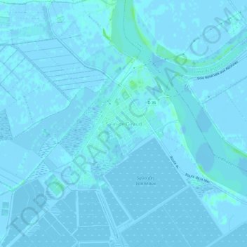
Name: Salin-de-Giraud topographic map, elevation, terrain.
Average elevation: 0 m
Minimum elevation: -5 m
Maximum elevation: 7 m
Make a donation
Gear up for your next adventure:
As an Amazon Associate, this site earns from qualifying purchases at no extra cost to you.
Other topographic maps
Click on a map to view its topography, its elevation and its terrain.
Étang de la Galére
France > Provence-Alpes-Côte d'Azur > Bouches-du-Rhône > Arles
Average elevation: -1 m
Raphèle-lès-Arles
France > Provence-Alpes-Côte d'Azur > Bouches-du-Rhône > Arles
Average elevation: 5 m
Marais de Meyranne
France > Provence-Alpes-Côte d'Azur > Bouches-du-Rhône > Arles
Average elevation: 2 m
Canal de Fumemorte
France > Provence-Alpes-Côte d'Azur > Bouches-du-Rhône > Arles
Average elevation: 0 m
Make a donation
Gear up for your next adventure:
As an Amazon Associate, this site earns from qualifying purchases at no extra cost to you.