
Make a donation
Gear up for your next adventure:
As an Amazon Associate, this site earns from qualifying purchases at no extra cost to you.
Cremona topographic map
Click on the map to display elevation.
Make a donation
Gear up for your next adventure:
As an Amazon Associate, this site earns from qualifying purchases at no extra cost to you.
Cremona
Cremona è situata nel sud della Lombardia, a contatto col fiume Po. Dista circa 30 km da Piacenza in Emilia-Romagna, 65 km da Mantova, 50 km da Lodi, 50 km da Brescia, 56 km da Parma in Emilia-Romagna, 75 km da Bergamo e 85 km da Milano. L'area del territorio comunale è di 70,4 km², l'altitudine media di 45 m s.l.m.
Make a donation
Gear up for your next adventure:
As an Amazon Associate, this site earns from qualifying purchases at no extra cost to you.
About this map
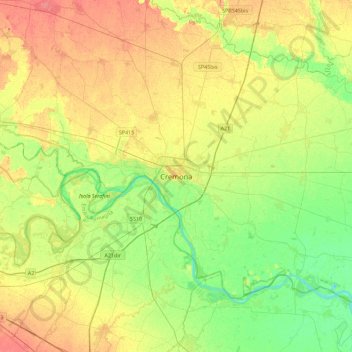
Name: Cremona topographic map, elevation, terrain.
Location: Cremona, Lombardia, 26100, Italia (44.97348 9.86487 45.29348 10.18487)
Average elevation: 45 m
Minimum elevation: 21 m
Maximum elevation: 73 m
Make a donation
Gear up for your next adventure:
As an Amazon Associate, this site earns from qualifying purchases at no extra cost to you.