Geolocate

Sheffield topographic map

Click on the map to display elevation.

About this map

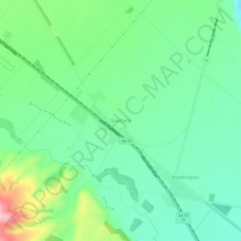
Name: Sheffield topographic map, elevation, terrain.

Location: Sheffield, Selwyn District, 7500, New Zealand (-43.40916 172.00113 -43.36916 172.04113)

Average elevation: 310 m

Minimum elevation: 264 m

Maximum elevation: 446 m

Other topographic maps

Click on a map to view its topography, its elevation and its terrain.

Lake Pearson

New Zealand > Selwyn District

Average elevation: 822 m

Torlesse Range

New Zealand > Selwyn District

Average elevation: 1,059 m

Big Ben Range

New Zealand > Selwyn District

Average elevation: 1,190 m

Craigieburn Range

New Zealand > Selwyn District

Average elevation: 1,168 m

Polar Range

New Zealand > Selwyn District

Average elevation: 1,454 m

Lake Minchin

New Zealand > Selwyn District

Average elevation: 1,092 m

Cascade Range

New Zealand > Selwyn District

Average elevation: 1,266 m

Cascade Range

New Zealand > Selwyn District

Average elevation: 1,266 m

Gear up for your next adventure:

🥾Trekking Poles - Adjustable trekking poles to reduce knee stress and improve stability
🔋Emergency Crank Radio - Weather alerts and power without needing batteries
🔭Compact Monocular - One-handed bird watching and trail spotting
🥾Mountain Trail Shoes - High-traction shoes for mountain trails
🪑Insulated Seat Pad - Protect your seat from cold rocks and wet logs

As an Amazon Associate, this site earns from qualifying purchases at no extra cost to you.