Geolocate

Bathad topographic map

Click on the map to display elevation.

About this map

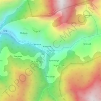
Name: Bathad topographic map, elevation, terrain.

Location: Bathad, Banjar, Kullu, Himachal Pradesh, India (31.58068 77.46151 31.62068 77.50151)

Average elevation: 2,550 m

Minimum elevation: 1,873 m

Maximum elevation: 3,392 m

Gear up for your next adventure:

🥫Freeze-Dried Meals - Lightweight, high-calorie nutrition for multi-day treks
🧴Sunscreen SPF - Broad-spectrum sunscreen for outdoor activities
🥾Light Trekking Boots - Supportive boots for multi-day treks
❄️Traction Ice Cleats - Slip-on spikes for icy trails and winter hiking
🧥Softshell Jacket - Windproof and breathable jacket for hiking

As an Amazon Associate, this site earns from qualifying purchases at no extra cost to you.