Geolocate

Humde topographic map

Click on the map to display elevation.

About this map

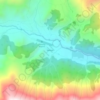
Name: Humde topographic map, elevation, terrain.

Location: Humde, Neshyang-04, Neshyang, Manang, Gandaki Province, Nepal (28.61822 84.07048 28.65822 84.11048)

Average elevation: 3,692 m

Minimum elevation: 3,304 m

Maximum elevation: 4,498 m

Other topographic maps

Click on a map to view its topography, its elevation and its terrain.

Neshyang-09

Nepal > Gandaki Province > Manang

Average elevation: 5,279 m

Neshyang

Nepal > Gandaki Province > Manang

Average elevation: 4,968 m

Gear up for your next adventure:

🧦Outdoor Socks - Durable socks designed for hiking and outdoor sports
🥫Freeze-Dried Meals - Lightweight, high-calorie nutrition for multi-day treks
🥾Mountain Hiking Boots - High-traction boots for rocky terrain
🚲MTB Frame Bag - Carry tools and maps directly on your bicycle frame
🥾Trail Running Shoes - Lightweight and durable shoes for trail running

As an Amazon Associate, this site earns from qualifying purchases at no extra cost to you.