Geolocate

Khandepar topographic map

Click on the map to display elevation.

About this map

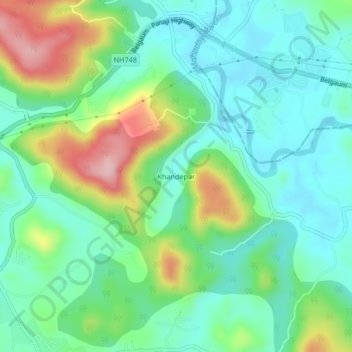
Name: Khandepar topographic map, elevation, terrain.

Location: Khandepar, Ponda, South Goa, Goa, 403406, India (15.38656 74.02632 15.42656 74.06632)

Average elevation: 63 m

Minimum elevation: 3 m

Maximum elevation: 203 m

Other topographic maps

Click on a map to view its topography, its elevation and its terrain.

Ponda

India > Goa > Ponda > Ponda

Average elevation: 62 m

Bandora

India > Goa > Ponda

Average elevation: 61 m

Gear up for your next adventure:

🧴Outdoor Sunscreen - High SPF protection for high-altitude UV exposure
🪑Insulated Seat Pad - Protect your seat from cold rocks and wet logs
🥾Mountain Hiking Boots - High-traction boots for rocky terrain
👟Sport Hiking Sandals - Breathable footwear for water crossings and camp rest
🧦Merino Wool Socks - Moisture-wicking comfort for long-distance hiking

As an Amazon Associate, this site earns from qualifying purchases at no extra cost to you.