Geolocate

Santa Ana topographic map

Click on the map to display elevation.

About this map

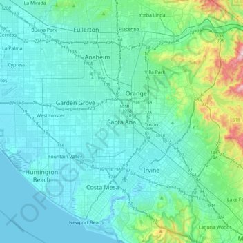
Name: Santa Ana topographic map, elevation, terrain.

Location: Santa Ana, Orange County, California, 82706, United States (33.58950 -118.03322 33.90950 -117.71322)

Average elevation: 83 m

Minimum elevation: -3 m

Maximum elevation: 667 m

Other topographic maps

Click on a map to view its topography, its elevation and its terrain.

Gear up for your next adventure:

🥾Lightweight Hiking Boots - Boots for comfort and mobility on long hikes
🥾Hiking Shoes - Durable and comfortable shoes for trail hiking
🦌Outdoor Trail Camera - Monitor wildlife activity near your favorite spots
🧥Waterproof Hiking Jacket - Protect yourself from rain and wind while hiking
🌡️Emergency Mylar Blankets - Compact thermal protection for unexpected nights outdoors

As an Amazon Associate, this site earns from qualifying purchases at no extra cost to you.