Geolocate

Winston topographic map

Click on the map to display elevation.

About this map
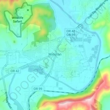
Name: Winston topographic map, elevation, terrain.

Location: Winston, Douglas County, Oregon, 97496, United States (43.10343 -123.45509 43.13990 -123.39360)

Average elevation: 196 m

Minimum elevation: 141 m

Maximum elevation: 442 m

Other topographic maps

Click on a map to view its topography, its elevation and its terrain.
Scottsburg

United States > Oregon > Douglas County

Average elevation: 168 m

Tenmile

United States > Oregon > Douglas County

Average elevation: 279 m

Umpqua

United States > Oregon > Douglas County

Average elevation: 137 m

Diamond Lake

United States > Oregon > Douglas County

Average elevation: 1,632 m

Dillard

United States > Oregon > Douglas County

Average elevation: 202 m

Rice Hill

United States > Oregon > Douglas County

Average elevation: 241 m

Glide

United States > Oregon > Douglas County

Average elevation: 259 m

Azalea

United States > Oregon > Douglas County

Average elevation: 604 m

Toketee Falls

United States > Oregon > Douglas County

Average elevation: 865 m

Tyee

United States > Oregon > Douglas County

Average elevation: 217 m

Cow Creek

United States > Oregon > Douglas County

Average elevation: 584 m

Wits End

United States > Oregon > Douglas County

Average elevation: 1,930 m

Azalea

United States > Oregon > Douglas County

Average elevation: 604 m

Gear up for your next adventure:

🎒Fully Waterproof Backpack - Total protection for photography gear and electronics
🧥Packable Rain Jacket - Breathable waterproof layer for unpredictable weather
👟Leg Gaiters - Keep debris, mud, and snow out of your boots
🪜Heavy Duty Carabiners - Multi-use clips for securing gear to your backpack
🧢Hiking Hat - Sun-protective and breathable hats for long treks

As an Amazon Associate, this site earns from qualifying purchases at no extra cost to you.