Geolocate

Rihana topographic map

Click on the map to display elevation.

About this map

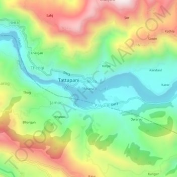
Name: Rihana topographic map, elevation, terrain.

Location: Rihana, Jeora, Karsog, Mandi, Himachal Pradesh, 175009, India (31.22674 77.07312 31.26674 77.11312)

Average elevation: 944 m

Minimum elevation: 608 m

Maximum elevation: 1,462 m

Gear up for your next adventure:

🕯️Camping Lantern - Illuminates your entire campsite with high-efficiency LEDs
🥾Hiking Shoes - Durable and comfortable shoes for trail hiking
👟Sport Hiking Sandals - Breathable footwear for water crossings and camp rest
🔥Emergency Fire Starter - Reliable ignition source for all weather conditions
🧤Insulated Winter Gloves - Heavy-duty protection for sub-zero Canadian adventures

As an Amazon Associate, this site earns from qualifying purchases at no extra cost to you.