Geolocate

Robledillo topographic map

Click on the map to display elevation.

About this map

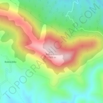
Name: Robledillo topographic map, elevation, terrain.

Location: Robledillo, Robledo del Mazo, Castilla-La Mancha, España (39.60364 -4.81243 39.60374 -4.81233)

Average elevation: 943 m

Minimum elevation: 786 m

Maximum elevation: 1,187 m

Gear up for your next adventure:

🥽Outdoor Goggles - Protective eyewear for outdoor activities
🥾Trekking Poles - Adjustable trekking poles to reduce knee stress and improve stability
🥾Waterproof Trail Shoes - Shoes designed to handle wet terrain
🚑Survival Whistle - Signal for help across long distances in mountains
🥤Collapsible Travel Cup - Saves space and weight in your mess kit

As an Amazon Associate, this site earns from qualifying purchases at no extra cost to you.