
Make a donation
Gear up for your next adventure:
As an Amazon Associate, this site earns from qualifying purchases at no extra cost to you.
Terhagen topographic map
Click on the map to display elevation.
Make a donation
Gear up for your next adventure:
As an Amazon Associate, this site earns from qualifying purchases at no extra cost to you.
Terhagen
Terhagen ligt aan de Rupel. De bodem is zandlemig en de hoogte varieert van 5 tot 30 meter. Het grondgebied van Terhagen is voor 50% gevormd door de steenindustrie en kleiputten. De baksteenindustrie is verdwenen in de jaren '70 van de 20e eeuw. Een museum en een groot aantal kleiputten zijn gebleven.
Make a donation
Gear up for your next adventure:
As an Amazon Associate, this site earns from qualifying purchases at no extra cost to you.
About this map
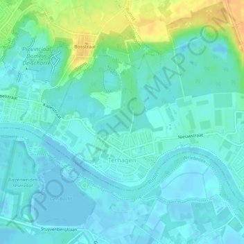
Name: Terhagen topographic map, elevation, terrain.
Location: Terhagen, Rumst, Antwerpen, België (51.07492 4.38519 51.09005 4.41021)
Average elevation: 7 m
Minimum elevation: -3 m
Maximum elevation: 30 m
Make a donation
Gear up for your next adventure:
As an Amazon Associate, this site earns from qualifying purchases at no extra cost to you.
Other topographic maps
Click on a map to view its topography, its elevation and its terrain.