
Geigelstein topographic map
Click on the map to display elevation.
Geigelstein
1991 wurden große Flächen des Geigelstein als Naturschutzgebiet Geigelstein ausgewiesen. Das NSG Geigelstein hat eine Größe von 3135 Hektar und liegt zum Teil im Landkreis Rosenheim mit der Gemeinde Aschau sowie im Landkreis Traunstein mit der Gemeinde Schleching. Mit einem der größten Schutzgebiete auf bayerischem Boden wird primär die empfindliche und seltene Alpenvegetation in den Höhenlagen geschützt. Der Ausweisung war eine über 15-jährige harte Auseinandersetzung von Befürwortern und Gegnern vorausgegangen.
About this map
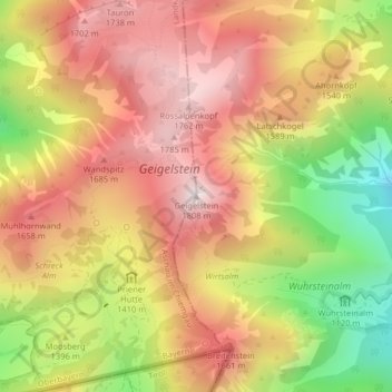
Name: Geigelstein topographic map, elevation, terrain.
Average elevation: 1,443 m
Minimum elevation: 972 m
Maximum elevation: 1,789 m
Other topographic maps
Click on a map to view its topography, its elevation and its terrain.
83229
Deutschland > Bayern > Landkreis Rosenheim > Aschau im Chiemgau > Schoßrinn
Average elevation: 904 m