Geolocate

Majada Labas topographic map

Click on the map to display elevation.

About this map

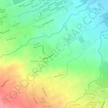
Name: Majada Labas topographic map, elevation, terrain.

Location: Majada Labas, Calamba, Laguna, Calabarzon, 4027, Philippines (14.18523 121.09470 14.20688 121.11974)

Average elevation: 104 m

Minimum elevation: 58 m

Maximum elevation: 161 m

Other topographic maps

Click on a map to view its topography, its elevation and its terrain.

La Mesa

Philippines > Laguna > Calamba

Average elevation: 240 m

88 Spa & Resort

Philippines > Laguna > Calamba

Average elevation: 83 m

San Juan River

Philippines > Laguna > Calamba

Average elevation: 9 m

Gear up for your next adventure:

🧭GPS Handheld Device - Reliable GPS navigation for outdoor adventures
🧴Sunscreen SPF - Broad-spectrum sunscreen for outdoor activities
🦶Anti-Blister Balm - Prevents friction and hotspots during long ascents
🧢Sun Protection Cap - Breathable cap to protect from sun exposure
🍽️Titanium Camping Spork - Ultralight and indestructible eating utensil

As an Amazon Associate, this site earns from qualifying purchases at no extra cost to you.