Geolocate

Lexington topographic map

Click on the map to display elevation.

About this map

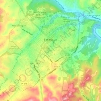
Name: Lexington topographic map, elevation, terrain.

Location: Lexington, Virginia, United States (37.76522 -79.46158 37.79478 -79.41530)

Average elevation: 330 m

Minimum elevation: 271 m

Maximum elevation: 394 m

Gear up for your next adventure:

🧴Waterproofing Spray - Restore the DWR coating on jackets and tents
🧥Thermal Layer - Insulating layer for cold outdoor conditions
Camping Tent - Weather-resistant tents suitable for 2 to 6 people
🧴Outdoor Sunscreen - High SPF protection for high-altitude UV exposure
🧢Beanie Hat - Keep your head warm in cold weather

As an Amazon Associate, this site earns from qualifying purchases at no extra cost to you.