Geolocate

Llançà topographic map

Click on the map to display elevation.

About this map

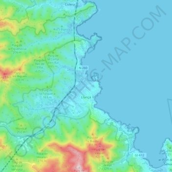
Name: Llançà topographic map, elevation, terrain.

Location: Llançà, Upper Empordà, Girona, Catalonia, 17490, Spain (42.34061 3.07682 42.39784 3.17477)

Average elevation: 93 m

Minimum elevation: -1 m

Maximum elevation: 503 m

Other topographic maps

Click on a map to view its topography, its elevation and its terrain.

Montgó

Spain > Catalonia > Upper Empordà > l'Escala

Average elevation: 17 m

Darnius

Spain > Catalonia > Upper Empordà > Darnius > Darnius

Average elevation: 208 m

Gear up for your next adventure:

🕶️Polarized Sunglasses - Protect your eyes with durable polarized lenses
🧴Insect Repellent - Protect yourself from bugs during outdoor adventures
🥾Mountain Hiking Boots - High-traction boots for rocky terrain
🔋Solar Power Bank - Keep your GPS and devices charged during long outdoor trips
🧳Compression Sacks - Maximize space in your backpack by shrinking gear

As an Amazon Associate, this site earns from qualifying purchases at no extra cost to you.