
Thank you for supporting this site ❤️
Make a donation
Make a donation
Gear up for your next adventure:
As an Amazon Associate, this site earns from qualifying purchases at no extra cost to you.
Larbaa topographic map
Click on the map to display elevation.
Thank you for supporting this site ❤️
Make a donation
Make a donation
Gear up for your next adventure:
As an Amazon Associate, this site earns from qualifying purchases at no extra cost to you.
About this map
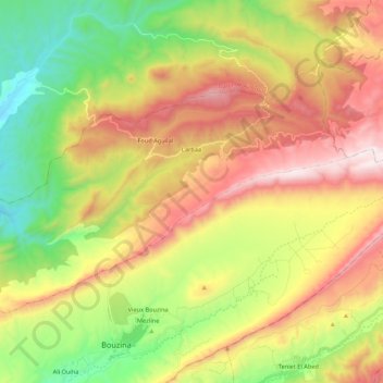
Name: Larbaa topographic map, elevation, terrain.
Location: Larbaa, Bouzina district, Batna, Algeria (35.27580 6.01325 35.39464 6.22828)
Average elevation: 1,487 m
Minimum elevation: 975 m
Maximum elevation: 2,120 m
Thank you for supporting this site ❤️
Make a donation
Make a donation
Gear up for your next adventure:
As an Amazon Associate, this site earns from qualifying purchases at no extra cost to you.