
Nebikon topographic map
Interactive map
Click on the map to display elevation.
About this map
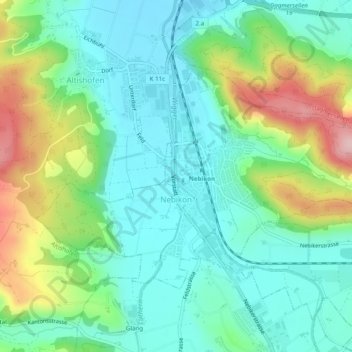
Name: Nebikon topographic map, elevation, terrain.
Location: Nebikon, Luzern, 6244, Schweiz (47.18115 7.95424 47.20250 8.00319)
Average elevation: 540 m
Minimum elevation: 475 m
Maximum elevation: 695 m
Im Westen der Gemeinde erhebt sich im Flüeggenwald das für das Amt Willisau typische hügelige Voralpengebiet, so dass Nebikon im Westen und im Osten von Anhöhen überragt wird.