Geolocate

Boyle topographic map

Click on the map to display elevation.

About this map

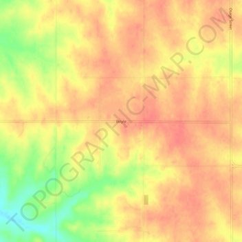
Name: Boyle topographic map, elevation, terrain.

Location: Boyle, Jefferson County, Kansas, United States (39.32028 -95.37275 39.36028 -95.33275)

Average elevation: 341 m

Minimum elevation: 300 m

Maximum elevation: 359 m

Other topographic maps

Click on a map to view its topography, its elevation and its terrain.

Perry Lake

United States > Kansas > Jefferson County

Average elevation: 303 m

Gear up for your next adventure:

🔨Vehicle Emergency Tool - Safety tool for remote road trips to trailheads
🥾Hiking Boots - Sturdy boots providing ankle support and traction on rugged trails
🧢Beanie Hat - Keep your head warm in cold weather
🪑Ultralight Camping Stool - Compact seating for rest stops during long hikes
🥾Trail Hiking Socks - Comfortable socks to prevent blisters and fatigue

As an Amazon Associate, this site earns from qualifying purchases at no extra cost to you.