
Saint Maurice Étusson topographic map
Interactive map
Click on the map to display elevation.
About this map
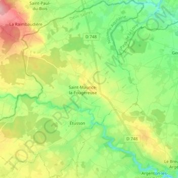
Name: Saint Maurice Étusson topographic map, elevation, terrain.
Average elevation: 128 m
Minimum elevation: 77 m
Maximum elevation: 211 m
Other topographic maps
Click on a map to view its topography, its elevation and its terrain.
Amuré
France > Nouvelle-Aquitaine > Deux-Sèvres
Amuré, Niort, Deux-Sèvres, Nouvelle-Aquitaine, Metropolitan France, 79210, France
Average elevation: 14 m
Le Bois Chapeleau
France > Nouvelle-Aquitaine > Deux-Sèvres > Beugnon-Thireuil
Le Bois Chapeleau, La Chapelle-Thireuil, Beugnon-Thireuil, Parthenay, Deux-Sèvres, Nouvelle-Aquitaine, Metropolitan France, 79160, France
Average elevation: 120 m
Seche Bec
France > Nouvelle-Aquitaine > Deux-Sèvres > Niort > Le Petit Chauveux
Seche Bec, Le Petit Chauveux, Quartier Nord, Niort, Deux-Sèvres, Nouvelle-Aquitaine, Metropolitan France, 79000, France
Average elevation: 47 m