
Make a donation
Gear up for your next adventure:
As an Amazon Associate, this site earns from qualifying purchases at no extra cost to you.
Orivesi topographic map
Click on the map to display elevation.
Make a donation
Gear up for your next adventure:
As an Amazon Associate, this site earns from qualifying purchases at no extra cost to you.
Orivesi
Orivesi has more than 350 lakes. The landscape of Orivesi is mostly dominated by Lake Längelmävesi, into which most of the area's water basis fall. The northeastern end of Kangasala's Lake Vesijärvi also extends to the Orivesi area. Some of the lakes in the western part of Orivesi flow into Lake Näsijärvi. The largest ridges in the town, which extend more than 200 meters above sea level, are located in the northwest near the borders of Tampere and Ruovesi. The average altitude of the terrain is 100–150 meters.
Make a donation
Gear up for your next adventure:
As an Amazon Associate, this site earns from qualifying purchases at no extra cost to you.
About this map
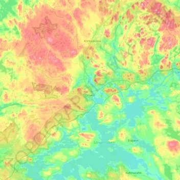
Name: Orivesi topographic map, elevation, terrain.
Average elevation: 127 m
Minimum elevation: 79 m
Maximum elevation: 222 m
Make a donation
Gear up for your next adventure:
As an Amazon Associate, this site earns from qualifying purchases at no extra cost to you.
Other topographic maps
Click on a map to view its topography, its elevation and its terrain.
Make a donation
Gear up for your next adventure:
As an Amazon Associate, this site earns from qualifying purchases at no extra cost to you.