Geolocate

Rzeszów topographic map

Click on the map to display elevation.

About this map

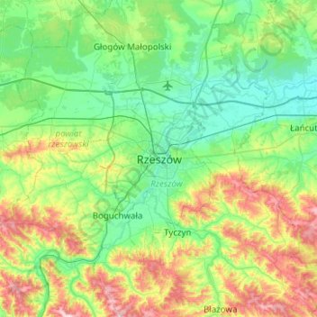
Name: Rzeszów topographic map, elevation, terrain.

Location: Rzeszów, Subcarpathian Voivodeship, 35-061, Poland (49.87745 21.84472 50.19745 22.16472)

Average elevation: 254 m

Minimum elevation: 184 m

Maximum elevation: 442 m

Gear up for your next adventure:

🛶Waterproof Dry Bags - Keep electronics and clothes dry during river crossings
🧭GPS Handheld Device - Reliable GPS navigation for outdoor adventures
🪑Insulated Seat Pad - Protect your seat from cold rocks and wet logs
🥾Hiking Boots - Sturdy boots providing ankle support and traction on rugged trails
🧥Insulated Jacket - Keep warm in cold outdoor conditions

As an Amazon Associate, this site earns from qualifying purchases at no extra cost to you.