
Make a donation
Gear up for your next adventure:
As an Amazon Associate, this site earns from qualifying purchases at no extra cost to you.
Olne topographic map
Click on the map to display elevation.
Make a donation
Gear up for your next adventure:
As an Amazon Associate, this site earns from qualifying purchases at no extra cost to you.
Olne
Olne ligt in het Land van Herve, op een hoogte van ongeveer 230 meter. Het ligt op een bergrug, met in noordelijke richting een korte steile helling naar de Ry de Rode en in zuidelijke richting een flauwere helling.
Make a donation
Gear up for your next adventure:
As an Amazon Associate, this site earns from qualifying purchases at no extra cost to you.
About this map
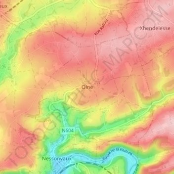
Name: Olne topographic map, elevation, terrain.
Location: Olne, Verviers, Luik, Wallonië, 4877, België (50.57012 5.72799 50.61012 5.76799)
Average elevation: 217 m
Minimum elevation: 106 m
Maximum elevation: 285 m
Make a donation
Gear up for your next adventure:
As an Amazon Associate, this site earns from qualifying purchases at no extra cost to you.