Geolocate

Winhall topographic map

Click on the map to display elevation.

About this map
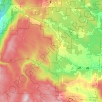
Name: Winhall topographic map, elevation, terrain.

Location: Winhall, Bennington County, Vermont, 05340, United States (43.11393 -73.00748 43.21089 -72.86214)

Average elevation: 578 m

Minimum elevation: 263 m

Maximum elevation: 881 m

Other topographic maps

Click on a map to view its topography, its elevation and its terrain.

North Pownal

United States > Vermont > Bennington County

Average elevation: 254 m

South Dorset

United States > Vermont > Bennington County

Average elevation: 377 m

Bondville

United States > Vermont > Bennington County > Winhall

Average elevation: 486 m

Bondville

United States > Vermont > Bennington County > Winhall

Average elevation: 486 m

South Dorset

United States > Vermont > Bennington County

Average elevation: 377 m

Gear up for your next adventure:

💡LED Headlamp - Hands-free illumination for night hiking and camping
🧥Waterproof Jacket - Lightweight rain jackets for hiking and outdoor activities
🪑Ultralight Camping Stool - Compact seating for rest stops during long hikes
🧊Insulated Water Bottle - Keeps drinks cold in summer and prevents freezing in winter
🧥Waterproof Pants - Keep dry during rainy hiking conditions

As an Amazon Associate, this site earns from qualifying purchases at no extra cost to you.