
Make a donation
Gear up for your next adventure:
As an Amazon Associate, this site earns from qualifying purchases at no extra cost to you.
Sarrazac topographic map
Click on the map to display elevation.
Make a donation
Gear up for your next adventure:
As an Amazon Associate, this site earns from qualifying purchases at no extra cost to you.
About this map
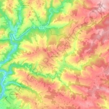
Name: Sarrazac topographic map, elevation, terrain.
Average elevation: 277 m
Minimum elevation: 156 m
Maximum elevation: 366 m
Make a donation
Gear up for your next adventure:
As an Amazon Associate, this site earns from qualifying purchases at no extra cost to you.
Other topographic maps
Click on a map to view its topography, its elevation and its terrain.
La Guillaumie
Frankrijk > Nieuw-Aquitanië > Dordogne > Saint-Aulaye-Puymangou > Saint-Aulaye
Average elevation: 63 m
Make a donation
Gear up for your next adventure:
As an Amazon Associate, this site earns from qualifying purchases at no extra cost to you.
Make a donation
Gear up for your next adventure:
As an Amazon Associate, this site earns from qualifying purchases at no extra cost to you.
Make a donation
Gear up for your next adventure:
As an Amazon Associate, this site earns from qualifying purchases at no extra cost to you.
Make a donation
Gear up for your next adventure:
As an Amazon Associate, this site earns from qualifying purchases at no extra cost to you.
Les Valades
Frankrijk > Nieuw-Aquitanië > Dordogne > Coux et Bigaroque-Mouzens
Average elevation: 155 m
La Rousille
Frankrijk > Nieuw-Aquitanië > Dordogne > Saint-Sulpice-d'Excideuil > La Rousille
Average elevation: 224 m
La Forge
Frankrijk > Nieuw-Aquitanië > Dordogne > Savignac-Lédrier > La Forge
Average elevation: 298 m
Make a donation
Gear up for your next adventure:
As an Amazon Associate, this site earns from qualifying purchases at no extra cost to you.
La Geneste
Frankrijk > Nieuw-Aquitanië > Dordogne > Coux et Bigaroque-Mouzens > La Geneste
Average elevation: 110 m