Geolocate

Pallipuram topographic map

Click on the map to display elevation.

About this map

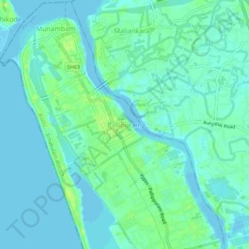
Name: Pallipuram topographic map, elevation, terrain.

Location: Pallipuram, Kochi, Ernakulam district, Kerala, 683515, India (10.14664 76.16332 10.18664 76.20332)

Average elevation: 5 m

Minimum elevation: -2 m

Maximum elevation: 13 m

Other topographic maps

Click on a map to view its topography, its elevation and its terrain.

Vypin

India > Kerala > Kochi > Edavanakkad

Average elevation: 3 m

Elamkunnapuzha

India > Kerala > Kochi > Elamkunnapuzha

Average elevation: 2 m

Gear up for your next adventure:

🚑Survival Whistle - Signal for help across long distances in mountains
🥾Trail Hiking Socks - Comfortable socks to prevent blisters and fatigue
🥾Mountaineering Boots - Supportive boots for climbing and high-altitude hiking
🧦Hiking Liner Socks - Thin base layer to prevent friction and blisters
👟Sport Hiking Sandals - Breathable footwear for water crossings and camp rest

As an Amazon Associate, this site earns from qualifying purchases at no extra cost to you.