Geolocate

Pleasant View topographic map

Click on the map to display elevation.

About this map

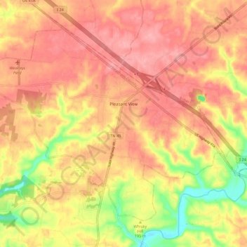
Name: Pleasant View topographic map, elevation, terrain.

Location: Pleasant View, Cheatham County, Middle Tennessee, Tennessee, United States (36.35331 -87.10046 36.42142 -86.99298)

Average elevation: 204 m

Minimum elevation: 137 m

Maximum elevation: 240 m

Other topographic maps

Click on a map to view its topography, its elevation and its terrain.

Beech Grove

United States > Tennessee > Cheatham County

Average elevation: 157 m

Marrowbone

United States > Tennessee > Cheatham County

Average elevation: 167 m

Germantown

United States > Tennessee > Cheatham County

Average elevation: 199 m

Gear up for your next adventure:

🧦Thermal Socks - Warm socks for winter hiking or camping
💧Collapsible Water Bottle - Space-saving water bottle for outdoor activities
🔨Vehicle Emergency Tool - Safety tool for remote road trips to trailheads
🧣Evaporative Cooling Towel - Beat the heat during intense summer climbs
👟Trail Running Shoes - Agile footwear for fast-paced topographic exploration

As an Amazon Associate, this site earns from qualifying purchases at no extra cost to you.